Sustainability has moved from being a desirable goal to an essential aspect of commercial real estate (CRE) development. Investors, tenants, and communities increasingly prioritize environmental responsibility, driving demand for properties that reflect these values. Drone technology, with its unique ability to provide detailed, actionable data, is becoming a powerful tool in achieving and promoting sustainable development.
Environmental, Social, and Governance (ESG) principles now heavily influence investor decisions, property valuation, and marketability. Sustainable buildings attract higher-quality tenants, enjoy increased occupancy rates, and often command premium rental prices. Additionally, sustainable real estate developments typically experience reduced long-term operational costs through energy efficiency and lower environmental compliance risks.
With global attention on climate change, investors and developers must respond proactively by embedding sustainability into their core strategies. Those who do not risk losing market share, facing regulatory hurdles, and encountering reputational challenges.
Traditionally, developers have faced substantial challenges when attempting sustainable real estate projects. Site assessments for sustainability have typically involved time-consuming, costly, and less precise methods. Traditional methods often fail to deliver accurate information on critical elements such as solar exposure, topography, and environmental constraints.
Additionally, effectively communicating sustainability initiatives to investors, tenants, and the community can be challenging using conventional marketing techniques, which often fall short in clearly illustrating environmental benefits.
Drones revolutionize the planning and development stages by providing comprehensive aerial assessments. With drones, developers and investors can accurately evaluate the suitability of sites for sustainability-focused development. Drone imagery allows teams to analyze topography, vegetation, water resources, and solar exposure comprehensively.
Accurate topographical surveys from drones help minimize the environmental footprint by informing optimal site layouts and construction methodologies. Additionally, drone technology enables precise analysis of solar potential, crucial for planning solar installations and optimizing renewable energy solutions.
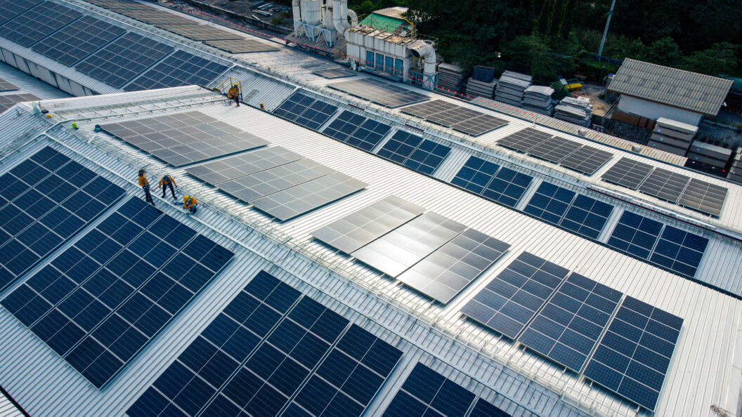
Drone technology efficiently assesses solar exposure, identifying optimal placement locations for solar panels to maximize energy production. High-resolution imagery captures shading patterns throughout the day, ensuring the solar installations’ maximum efficiency.
Green Roof and Landscaping Optimization
Drones capture detailed aerial data to inform the design and placement of green roofs, urban gardens, and sustainable landscaping. This ensures effective water management, biodiversity enhancement, and reduced urban heat island effects.
Sustainable Site Design
Drone-generated maps enable developers to plan site infrastructure with minimal environmental disruption. The technology aids in selecting construction staging areas, pathways, and layouts to avoid sensitive habitats and maintain ecological integrity.
Environmental Compliance and Monitoring
Drones perform routine environmental inspections efficiently, enabling ongoing monitoring of compliance with sustainability standards and identifying environmental issues early, allowing prompt corrective actions.
Drone visuals provide an engaging medium to transparently showcase a property’s sustainability features. Investors and tenants gain clarity and confidence when sustainability initiatives are clearly visualized. High-quality drone footage and imagery effectively communicate renewable energy installations, green roofs, sustainable water management systems, and community green spaces.
These dynamic visuals powerfully position properties as leaders in sustainability, differentiating them in competitive markets and enhancing their desirability among environmentally conscious investors and tenants.
Drone technology directly impacts the bottom line by significantly enhancing the financial returns of sustainable real estate developments. Detailed drone data contributes to reduced project costs and enhanced operational efficiency, directly affecting profitability.
- Improved Resource Allocation: Drone-generated accurate site analyses and topographical data reduce waste and unnecessary resource consumption during construction, translating into significant cost savings.
- Enhanced Energy Efficiency: Precision drone data facilitates optimized energy solutions, leading to substantial long-term savings in operational expenses.
- Lower Environmental Impact Fees: Comprehensive and precise data helps maintain compliance with environmental regulations, reducing risks of penalties and fees related to environmental impacts.
The accuracy and detail provided by drone data elevate investor confidence, promoting higher property valuations and improved long-term profitability. This clear quantification of sustainability initiatives’ benefits further solidifies the financial and market case for investing in environmentally conscious developments.
Drone technology continues to evolve rapidly, promising even greater contributions to sustainable real estate practices. Future innovations include:
- AI-driven Sustainability Analysis: Advanced analytics that automatically assess environmental impacts and suggest optimal sustainable development strategies.
- Automated Monitoring Systems: Continuous drone-driven environmental monitoring, ensuring ongoing compliance and operational sustainability.
- Virtual Reality Integration: Enhanced immersive experiences through VR, powered by drone-captured data, allowing stakeholders to fully experience sustainable development projects remotely and in detail.
Early adopters of these drone-driven solutions will position themselves advantageously, prepared for future regulatory shifts and aligning themselves firmly with evolving investor and tenant expectations.
Drone technology is a transformative tool for sustainable real estate development, enhancing everything from initial site assessment and planning to ongoing environmental compliance and effective marketing. By integrating drones into their sustainability strategies, developers and investors can achieve greater efficiency, reduce costs, and meet increasing demands for environmentally responsible real estate.
Up Sonder is dedicated to supporting your sustainability goals through cutting-edge drone solutions. Visit UpSonder.com today to explore how drone technology can advance your sustainable real estate development projects, positioning you as a leader in green development.