Understanding the 400-Foot Flight Ceiling and Why It Exists
One of the most important rules for drones in the United States is the 400-foot flight ceiling. This means that under Federal Aviation Administration (FAA) regulations, drones cannot be flown higher than 400 feet above the groundin most situations . The rule applies to both recreational hobbyists and commercial drone pilots (like those flying for real estate jobs) and has a very good reason behind it: airspace safety.
Commercial airplanes and helicopters usually fly at higher altitudes, generally 500 feet or above except during takeoff and landing . By capping drones at 400 feet, the FAA creates about a 100-foot safety buffer to help prevent close calls or collisions between small drones and manned aircraft . In other words, staying below 400 feet keeps drones a safe distance away from most manned aircraft operations in the sky . There have been many reports of near-misses in the past when drones wandered too high – and even a small drone could cause serious damage if it struck an airplane or helicopter. The 400-foot ceiling was adopted (similar to rules in many other countries) to greatly reduce this risk . In fact, regulators chose 400 feet after initially considering 500 feet, specifically to add extra padding for safety . The rule has been widely accepted in the drone community as a sensible compromise that allows useful drone flights but protects the National Airspace and everyone’s safety .
In plain terms: drones must “stay low” so that airplanes can fly higher. This separation gives pilots of manned aircraft peace of mind that they won’t suddenly encounter a drone at their altitude, and it gives drone operators a clear maximum to plan around. Remember, it’s ultimately the drone operator’s responsibility to avoid manned aircraft at all times . The 400-foot limit helps make that easier by keeping drones well below where most planes normally cruise. It’s an FAA rule across the entire United States, so no matter what state you’re in, 400 feet above ground level (AGL) is the standard ceiling for drone flights (with only a few specific exceptions we’ll discuss later).
Controlled vs. Uncontrolled Airspace (and No-Fly Zones)
Another key factor affecting where and how high drones can fly is the type of airspace you’re in. The FAA divides the skies into different classes of airspace. For our purposes, you mainly need to know about “controlled” vs “uncontrolled” airspace:
- Controlled Airspace: This is airspace where air traffic control services are provided – typically around airports (Class B, C, D airspace) or in certain high-altitude corridors (Class E extending from the surface). In controlled airspace, manned air traffic is actively managed by air traffic controllers . Examples include the skies near large commercial airports or major metropolitan areas. Drones are not allowed to fly in controlled airspace without special permission from the FAA . If you are near an airport, even as a licensed drone pilot, you must request an airspace authorization before flying. These authorizations will come with specific altitude limits and other conditions to ensure safety . In fact, some controlled zones near airport runways are completely off-limits (0 feet altitude allowed) for drones because of the high risk. This is why drones may not be able to fly at all in certain areas, usually close to airport approach/departure paths or sensitive locations like Washington D.C.’s downtown airspace.
- Uncontrolled Airspace: This refers to airspace where there is no active air traffic control managing low-level flights – in other words, areas away from airports and not in other restricted zones . Most of the country’s airspace below 400 feet AGL is actually uncontrolled (Class G) airspace. In uncontrolled airspace, drone pilots do not need any prior permission to fly, as long as they follow the standard rules (such as the 400 ft ceiling and keeping the drone within line of sight) . You can think of uncontrolled airspace as the “open skies” for drones, up to that 400 ft limit. However, uncontrolled doesn’t mean unimportant – many small aircraft (like hobbyist planes or helicopters) can still fly through these areas. So drone operators must still be vigilant and yield to any manned aircraft traffic, even out in the countryside. The FAA reminds us that there are many private pilots who fly at low altitudes in uncontrolled airspace, and they usually cannot see a drone until it’s too late to avoid it . So staying under 400 ft and staying aware of your surroundings is critical everywhere.
It’s worth noting that “no unregulated airspace” exists – the FAA governs the entire National Airspace System one way or another . Even in uncontrolled Class G airspace, drones are regulated by rules like the 400 ft limit and other operational guidelines. And aside from controlled airspace around airports, there are other restricted zones where drones can’t fly without special clearance. Examples include Temporary Flight Restrictions (TFRs) over events (like stadium games or wildfire areas), prohibited areas like near military bases or the Washington D.C. downtown core, and national parks (which ban takeoff/landing of drones). As a real estate agent, the most common airspace issue you’ll encounter is proximity to an airport. If a property you want to film is within roughly five miles of a busy airport, it’s likely in controlled airspace where special steps must be taken before any drone flight. If it’s in a typical suburban or rural area far from airports, it’s probably uncontrolled airspace – meaning a licensed drone pilot can operate there up to 400 ft AGL by default .
In short: drones can freely fly up to 400 ft in most uncontrolled airspace (with a vigilant eye for other aircraft), but near airports or in other controlled/restricted zones, extra planning and FAA permission is required before a drone ever leaves the ground. Always ask your drone operator if any airspace restrictions apply to your listing’s location – companies like Up Sonder will always check this in advance as part of their safety protocol.
Why 400 Feet Matters for Real Estate Photos & Videos
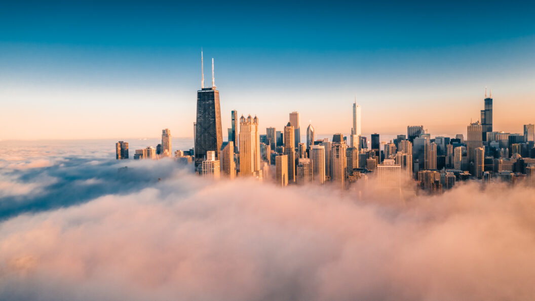
You might be wondering how this 400 ft limit actually affects the shots you can get of a property. After all, 400 feet (about 120 meters) is roughly the height of a 30 to 40-story building – which is quite high! In practice, flying up to 400 ft allows for very dramatic wide-angle views of a property and its surrounding neighborhood. For example, at 400 ft a drone can usually see not just the home and yard, but also the broader neighborhood layout, nearby parks or amenities, and even city skylines on the horizon in some cases . This altitude is typically more than enough to capture the “bird’s eye view” that clients love, such as a sweeping shot of a house with the landscape or city in the background.
However, the 400 ft rule does set a hard cap on just how broad a view you can get in a single shot. For instance, if a client asks, “Can’t we go higher to get the whole town in the photo?”, a responsible drone operator will explain that going above 400 ft without authorization is illegal. While 400 ft provides a plenty wide perspective for most real estate needs, it does mean we can’t simply fly up to 800 ft or 1000 ft to fit more into the frame. Drones have to work within that altitude window, which sometimes requires a bit of creativity from the pilot.
For example, to achieve a super wide overview of a large luxury estate or a farm property, the drone pilot might take a panorama (stitching multiple photos together) at 400 ft, rather than one photo from a higher altitude. Or the pilot might back away and fly at a lower height from a further distance to capture more of the landscape while still keeping under the ceiling. The good news is that 400 feet is generally plenty high for real estate imagery – in many cases, drone pilots don’t even need to max out that altitude to get great shots . Often, excellent angles are found at 100 ft, 200 ft, etc., depending on what aspect of the property you want to highlight (the roof details versus the entire acreage, for example). In fact, for some smaller residential properties, going the full 400 ft up might be higher than necessary, as the house could appear very small in the frame from that height .
The key point to set client expectations is: a drone will showcase your listing from a high vantage point, but within the legal limit. You can get stunning “overhead” photos of the home, expansive shots showing the neighborhood context, and smooth aerial video that gives a tour of the property – all without ever breaking the 400 ft rule. What you won’t get (nor should you expect) is a drone shot from, say, 1000 feet in the air looking miles in every direction like a Google Earth satellite image. For those extremely high angles, you would need a helicopter or airplane (and separate FAA approvals) – which is outside the scope of normal real estate marketing. Fortunately, for selling real estate, views from ground level up to a few hundred feet are usually ideal. They provide enough scope to make the property stand out and look impressive, without losing the details. The 400 ft ceiling simply draws the line at the upper end of that range.
“Can’t We Just Go Higher?” – Why Drone Pros Stick to the Limit
It’s tempting to think, “if a higher altitude would get an even more amazing shot, why not just try it?” But professional drone operators cannot and will not simply go above 400 ft on a whim – and neither should anyone. Here’s why:
- It’s the Law: As discussed, the 400 ft limit is a federal regulation (under 14 CFR Part 107 for commercial drones) that applies nationwide . Flying above that without a waiver is illegal, plain and simple. A reputable drone pilot or company will always follow FAA rules, both for safety and because violations can lead to stiff penalties. If caught flying a drone higher than 400 ft AGL without authorization, a pilot can face significant fines and even potential loss of their license. The FAA has enforced actions against drone operators for reckless high-altitude flights in the past. In short, asking a drone pilot to break this rule is like asking a driver to speed through a school zone – no professional is going to agree to it. It’s not worth the risk to safety or the pilot’s certification.
- Safety and Liability: Above 400 ft, the risk of encountering a manned aircraft (like a low-flying helicopter or small plane) increases. Drone pilots have a duty to avoid other aircraft. If an operator went higher and a near-miss or collision occurred, it could be catastrophic. Not only would this endanger lives, but it would also create huge liability issues. No client’s marketing photo is worth a collision between a drone and a news helicopter or crop duster. By staying at or below 400 ft, drone flights remain in a zone where manned aircraft are far less likely to be operating, greatly reducing the chance of a mid-air conflict . It’s also easier for the drone pilot to see and avoid any aircraft that do pass through the area.
- Drone Capability: Many modern drones actually have software “geo-fencing” that prevents them from exceeding 400 ft AGL unless explicitly overridden (which only licensed pilots with waivers can do). The drone’s GPS and barometer know its altitude and will simply stop ascending once it hits ~400 ft. This is a built-in compliance feature on popular models to help pilots obey the law . Additionally, drones are optimized to fly at lower altitudes – going extremely high can strain battery life and control connections. The higher you go, the stronger the winds and the more challenging it can be to maintain stable control or get the drone back home safely. In fact, most drone pilots prefer to fly well below the limit for better shots and easier operation, only approaching 400 ft when specifically needed for a wide view .
- Legal Approvals Take Time: Even though it is possible to get FAA permission to go above 400 ft (more on that next), it’s not something you can do on the spot. It requires going through official channels and paperwork. If a real estate agent shows up at a property and asks the pilot, “Hey can we go up to 600 ft for this one shot?”, the answer will be no, because there’s no instantaneous way to get that approved. Thus, in practical terms, the 400 ft ceiling is a firm, non-negotiable limit for any spur-of-the-moment or scheduled real estate drone shoot.
Drone operators can’t simply “go higher” for a more dramatic view because it’s unsafe and illegal to do so without prior authorization. The limit exists to protect everyone in the air. A professional pilot’s job is to get the best possible images within the constraints of the law – and there is still plenty of room for creativity under 400 ft. If a client ever pushes to break the rules (“just this once”), a good operator will educate them on why that’s not an option. It’s our responsibility to set those expectations clearly (hence this blog!), so you understand the reasoning and won’t be disappointed when your drone team respectfully declines an out-of-bounds request.
Going Above 400 Feet or Into Restricted Airspace: What Does It Take?
By now, you might be curious: Is it ever possible to legally exceed the 400 ft limit? And what if a property is in controlled airspace near an airport – can you still fly there at all? The answer to both is yes, but only with proper authorization, and obtaining those approvals is a complex process that requires advanced planning.
- LAANC Authorizations for Controlled Airspace: If your listing is near a smaller airport or on the edge of controlled airspace, a drone pilot can often use the Low Altitude Authorization and Notification Capability (LAANC) system to request clearance. LAANC is an automated system the FAA provides through various apps, allowing licensed Part 107 pilots to get real-time approval to fly in certain controlled airspace sectors, usually up to a specific altitude . For example, near a certain airport, LAANC might allow drone flights up to 100 feet, 200 feet, etc., in that area. The drone pilot enters the flight plan and requested altitude, and if it’s within the FAA’s preset limits for that grid, authorization is granted almost instantly. LAANC is fantastic for enabling flights in what would otherwise be no-fly zones, but it does not allow going above the normal altitude limit – it only grants permission to fly at all in a controlled area, up to the altitude cap set by the FAA. Even with LAANC, you’re still constrained by whatever altitude the system and maps allow (never more than 400 ft, and often less). In Class B airspace near big airports, for instance, LAANC might only allow 0–100 ft in some grids, or it may not be available at all right next to runways . If LAANC isn’t available or you need higher than those presets, the pilot would have to request a manual airspace authorization via the FAA DroneZone website – a process that can take days or weeks for approval.
- Part 107 Waivers (Section 107.51 Waiver for Altitude): To actually fly a drone above 400 feet AGL, a remote pilot must obtain a Part 107 waiver specifically for altitude. This is an official FAA approval that essentially says, “We grant an exception to the 400 ft rule for this operation because the operator has proven they can do it safely.” Getting such a waiver is not easy. The pilot has to apply through FAA’s DroneZone portal, explaining in great detail the what, where, when, and how of the proposed operation, and how they will mitigate any risks . They might need to outline safety procedures like having visual observers, using ADS-B receivers to detect nearby aircraft, etc., to ensure no conflict with manned planes. The FAA reviews these requests carefully, and only a handful of waivers to fly above 400 ft have ever been granted (usually for very specialized tasks like infrastructure inspections or research in remote areas) . For a real estate listing, it is generally not feasible to obtain a 400+ ft altitude waiver – not because real estate isn’t important, but because the FAA is unlikely to deem it necessary when fantastic imagery can be captured at 400 ft or below. Moreover, the timeline is prohibitive: the FAA recommends applying at least 90 days in advance for any waiver . Yes, three months! Even a straightforward request can take weeks to process, and more complex ones longer. Real estate deals move faster than that – by the time an altitude waiver was approved, the property might be off the market or under contract. This is why we say most real estate agents do not (and cannot) build such long lead times into their listing schedules for drone shoots. It’s just not practical.
- Other Special Approvals: There are other scenarios like flying at night or over people, which also require waivers or meeting strict conditions, but those are beyond the scope of the 400 ft discussion. The main thing to remember is any deviation from the standard rules must be approved by the FAA first. A professional drone company will handle these approvals if they are ever needed, but it requires sufficient notice. For example, if Up Sonder were tasked with a project that truly required a height above 400 ft or a flight in a tightly restricted zone, we would coordinate the paperwork and clearance – but this would be discussed well in advance with the client, including the extra time and cost involved in securing a waiver. In our experience with real estate marketing, such needs are extremely rare.
To put it simply: flying higher or in restricted airspace is possible only through formal FAA authorization (LAANC or waivers), which takes planning and cannot be done last-minute. If your property listing is near an airport or you anticipate wanting an unusual shot that might push regulatory boundaries, let your drone provider know as early as possible. They can then advise on what’s feasible and initiate any approval processes if appropriate. Most of the time, though, a skilled pilot can get all the shots you need legally without having to resort to special permissions – it’s amazing what can be achieved under 400 feet!
Up Sonder’s Commitment to Legal, Safe Drone Operations
At Up Sonder, we take these regulations very seriously – and you should only work with drone operators who do the same. All of our drone pilots are FAA-certified professionals who have passed the Part 107 Remote Pilot exam and understand the airspace rules inside and out . We pride ourselves on being 100% compliant with FAA guidelines at all times. What does this mean for you, the client?
- Airspace Checks for Every Flight: Up Sonder pilots will always evaluate the airspace for your shoot location ahead of time. If the property is in controlled airspace (e.g., near an airport), we will handle obtaining a LAANC authorization or airspace waiver as needed before the day of the shoot. We’ll let you know if there are any limitations (for example, “this home is 1 mile from a busy airport, so we are only authorized up to 200 ft for our drone shots”). We’ll also advise on scheduling if, say, extra lead time is required for an authorization request. You won’t be left in the dark – we explain any airspace constraints upfront so expectations are clear.
- Safety-First Approach: Our pilots adhere strictly to the 400 ft ceiling and all other operational rules (like keeping line-of-sight, not flying over uninvolved people without a waiver, etc.). By staying within the law, we ensure the safety of everyone on the ground and in the air, and you as the client can have peace of mind. We carry appropriate insurance and maintain high standards of safety on every flight. No photo or video is worth taking a risk on safety or legal compliance. Luckily, we can get amazing results without ever risking a violation.
- Top-Tier Results Within Legal Limits: Working within the regulations doesn’t mean you get subpar imagery – far from it. Our network of pilots has the expertise to maximize what’s possible under 400 ft. We use state-of-the-art drones with high-resolution cameras to capture stunning aerial photos and 4K videos that make properties shine. Whether it’s a sprawling ranch or a downtown high-rise (where we might fly around the building up to roof height), we’ll find creative solutions to get the wow-factor shots while following the rules. Clients are often amazed at the angles and quality we deliver, all without bending any rules. We like to say, “It’s our job to know the rules so well that we can push the creative envelope inside of them.”
- Handling Approvals and Logistics: If an operation does require special permission, Up Sonder will handle the heavy lifting of working with the FAA. For instance, if a luxury estate sits right next to an airport’s approach path, we will coordinate with the FAA (and possibly airport officials) to secure a window for the flight, or schedule at a time with minimal airport traffic, etc. We build in the needed lead time for these discussions. From the client’s perspective, you don’t have to navigate the bureaucratic maze – that’s our responsibility as your drone service provider. We’ll simply inform you of any necessary limitations or schedule adjustments. Our goal is to deliver the best visuals possible, legally and safely, so you never have to worry about compliance issues coming back to bite you.
In essence, Up Sonder operates as a trusted partner, ensuring that your drone photography adheres to FAA rules like the 400 ft ceiling while still achieving your marketing objectives. We educate clients (through resources like this blog) so you understand why certain constraints exist. When your seller asks “Why can’t the drone go higher to see the whole town?”, you’ll have a clear answer – and you can reassure them that the shots will still be fantastic at legal altitudes.
By setting realistic expectations and following the law, we not only avoid legal trouble but also uphold the professionalism of your real estate business. The last thing you want is an illegal drone flight causing an accident or attracting an FAA investigation during a listing – that would cast a very poor light on your brokerage. With Up Sonder, you can rest easy knowing every flight is conducted with full compliance. We want the focus to be on the stunning aerial views of your property, not on any regulatory headaches!
Setting Expectations and Soaring Within the Limit
To wrap up, the FAA’s 400-foot drone flight ceiling is a crucial rule designed to keep our skies safe. It does impose some boundaries on drone photography, but as we’ve outlined, it’s more than possible to create breathtaking real estate photos and videos while respecting the 400 ft limit. As a client, understanding this rule helps you set the right expectations with your drone photographer and your sellers. You now know what’s possible, what isn’t, and most importantly why.
When you hire Up Sonder (or any licensed drone operator), you’re not just paying for cool photos – you’re paying for expertise and compliance. We handle the nitty-gritty of airspace classes, waivers, and authorizations so that you can focus on marketing the property. By working within the FAA’s rules, we ensure that every drone shoot is not only successful and stunning, but also safe and responsible.
So the next time a seller asks, “Can the drone get a view from way up there?”, you can confidently explain: “Drones are legally capped at 400 feet, which is about a 30-story building high. That’s actually plenty for a gorgeous wide shot – and our drone team will get everything we need within that height. They always follow the FAA rules, which keep everyone safe. Going higher isn’t allowed without special waivers that take months, but don’t worry, 400 feet will do the job!” Your clients will appreciate the clarity and professionalism.
In the end, adhering to the 400 ft ceiling isn’t a limitation so much as it is the playing field on which we operate. And within that field, there’s a lot we can do! Up Sonder is committed to delivering top-tier results within the law, so you get all the benefits of aerial real estate imagery with none of the concerns. We hope this explanation has demystified the 400 ft rule and airspace basics for you. Should you have any more questions about drone flight limits or how we ensure compliance on our missions, please don’t hesitate to reach out at UpSonder.com. Here’s to safe flights and spectacular views for all your future listings!