In the realm of real estate, the introduction of drone technology has ushered in a revolutionary transformation. Originally developed for military purposes, drones have rapidly adapted to the commercial sector, fundamentally altering the way we showcase and survey properties.
From their military origins, drones have undergone substantial evolution. Today’s models are equipped with high-resolution cameras, GPS precision, and advanced flight controls, rendering them indispensable tools in the real estate industry. These modern drones go beyond capturing aerial shots; they encompass a wide range of functionalities, from 3D mapping to thermal imaging. The future promises even more remarkable advancements, including improved autonomy, extended battery life, and seamless integration with artificial intelligence, poised to further revolutionize their applications.

Compared to traditional methods, drones stand out for their efficiency and accuracy. They not only offer a quicker turnaround but also provide a more comprehensive view of properties, all at a significantly reduced cost. A study comparing traditional surveying methods with drones underscores the effectiveness of drone technology in real estate.
Operating drones for commercial purposes entails adhering to specific regulations, with the Federal Aviation Administration (FAA) setting guidelines in the United States. Globally, drone laws vary, making compliance a crucial aspect for real estate professionals using this technology.
As we delve deeper into this transformative journey, it becomes evident that drones are not mere flying cameras but potent tools for data collection and analysis, reshaping the landscape of real estate marketing and property assessment.
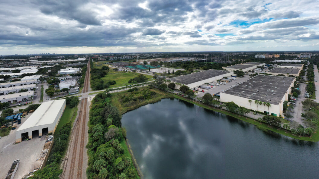
Recently, Up Sonder demonstrated the power of drone technology in real estate analysis by capturing detailed images in Pompano Beach, FL, South Florida’s largest development. Through advanced imaging capabilities, our drones gathered high-resolution aerial views, offering a comprehensive understanding of the property’s layout, topography, and surrounding area. Up Sonder secured FAA authorization for restricted airspace, providing vital data instrumental in creating an informative offering memorandum. By processing and analyzing this aerial data, the client gained valuable insights that guided investment decisions and strategic planning. Up Sonder’s expertise in drone technology adds significant value in real estate, transforming mere images into crucial data for informed decision-making.
Moving beyond aerial drone capabilities, we venture into the emerging world of indoor drone inspection and analysis. While Up Sonder primarily focuses on outdoor drone applications, the industry witnesses a growing interest in indoor drone technology.
Indoor drones, specifically designed for confined spaces, come equipped with specialized sensors and software. These features address the challenges of indoor navigation, offering valuable insights in complex environments. In the real estate sector, indoor drones are increasingly used for property inspections and surveillance, providing a safer and more efficient alternative to traditional methods. The integration of indoor drone footage with virtual reality is opening new avenues for property showcasing, enabling immersive experiences that enhance client engagement.
Further exploring the applications of drone technology at Up Sonder, we find a crucial area where drones are making a significant impact: environmental assessments in real estate. In the world of commercial real estate, understanding and mitigating environmental impact are vital. Drones offer an innovative approach to monitoring ecological footprints, allowing for detailed data collection on local flora and fauna, aiding in assessing how development projects might impact the environment. Drones are instrumental in planning eco-friendly developments, providing essential data that helps balance construction needs with environmental conservation. For instance, a recent project utilized drone footage to plan a development that harmoniously blended with the local ecosystem. Navigating environmental laws is a significant aspect of real estate development, and drones can play a pivotal role in ensuring projects comply with these regulations, offering a new perspective in environmental stewardship.
As we explore the multifaceted benefits of drones, it’s clear they’re not just tools for property inspection but also allies in promoting sustainable development and regulatory compliance in the real estate sector.
At Up Sonder, we’ve witnessed firsthand the economic advantages of utilizing drones in real estate assessments. Drones offer a cost-effective solution compared to traditional survey methods, resulting in significant savings in both time and resources, as evidenced by a financial case study where drone usage reduced operational costs by a considerable margin. Our drone technology has been pivotal in uncovering the true potential of properties, often leading to an increase in their market value. A notable example is a property whose hidden features, revealed by drone footage, significantly enhanced its appeal and price. Drones are not just tools for assessment; they are also valuable for identifying lucrative investment opportunities. By providing detailed data and insights, drones help investors make informed decisions, often uncovering hidden gems in the real estate market.
As we continue to embrace drone technology, we’re excited about the evolving role of drones in real estate. The adoption of drones in the real estate sector is on a sharp rise, creating a competitive landscape where the use of drone technology differentiates property marketing and analysis. Innovations like AI, machine learning, and autonomous drones are reshaping our approach, enhancing efficiency, and opening up new possibilities in property assessment and marketing. Looking towards 2030, we anticipate significant shifts in the market, with drone technology becoming even more integrated into the real estate industry. We foresee a future where drones are central to the real estate scene, offering innovative solutions for market challenges. As the saying goes, “Technology is not just a tool, it reshapes the landscape it is used in,” and in the realm of real estate, drone technology is revolutionizing the roles of professionals and the expectations of clients.
Drones are redefining skill sets and creating new career opportunities in the real estate industry. One notable anecdote involves a professional who significantly expanded their expertise after embracing drone technology. Clients now expect more detailed and immersive property insights, which drones readily provide. A narrative of a client’s experience with drone-assisted real estate showcases the enhanced service quality. The necessity for specialized knowledge and certifications in drone operation is becoming more prevalent, and training programs are emerging to equip realtors with these skills.
This sets the stage to explore global perspectives on drone technology in real estate, highlighting its worldwide impact. The use of drones in real estate is a global phenomenon, but it varies widely due to differing international regulations and market demands. The landscape of drone laws is as diverse as the countries themselves. While some regions embrace drone technology in real estate, others have stricter regulations that limit its use. In urban areas, drones are often used for high-rise building inspections and marketing, whereas in rural settings, they’re more commonly employed for land surveys and agricultural assessments. Collaborating across borders in drone projects presents unique challenges, particularly in aligning technological capabilities and adhering to varying legal frameworks. Understanding these global nuances is crucial as we further delve into the technological aspects of drone operations. What truly elevates drones in the realm of real estate is the sophisticated software behind them. Drone software is the cornerstone of their functionality, enhancing capabilities from flight control to data analysis. At Up Sonder, we utilize advanced software to maximize these functionalities. Handling the vast data collected by drones is crucial. We focus on efficient data processing and secure cloud storage to manage this information.
Even with their transformative impact, drones in real estate face challenges and limitations inherent in drone usage, a critical aspect for professionals in the industry. Issues like limited battery life and sensitivity to weather conditions can affect drone operations. Balancing the benefits of drone surveillance with privacy rights is crucial, and we adhere to ethical guidelines and privacy laws, ensuring respectful and lawful use of drones. Innovations in drone technology are continually addressing these challenges, with collaborative problem-solving enhancing the efficiency and effectiveness of drones in real estate.
Reflecting on our journey through the world of drones in real estate, it’s evident that they offer transformative potential. From enhancing property valuation to assisting in eco-friendly development, drones are reshaping the industry. At Up Sonder, we look ahead to a future where drones play an integral role in driving innovation and efficiency.
We’re excited to be part of this ongoing evolution, continually exploring new possibilities in drone technology. The real estate landscape is undergoing a remarkable shift, and drones are at the forefront of this transformation. As we continue to leverage drone technology, we anticipate even greater advancements and a more seamless integration of drones into every facet of the industry.
In the words of renowned architect and visionary Buckminster Fuller, “You never change things by fighting the existing reality. To change something, build a new model that makes the existing model obsolete.” In the realm of real estate, drones are not merely changing the game; they are building a new model that revolutionizes the roles of professionals, the expectations of clients, and the future of the industry itself.
As we conclude our exploration of the impact of drones on real estate, we invite you to join us on this exciting journey into the future, where the sky is not the limit but the starting point for innovation and transformation. Together, we will continue to push the boundaries of what is possible in the world of real estate with the help of this remarkable technology.