Commercial real estate investors spend their days evaluating opportunities. Some are analyzing dozens of properties every week. Others are reviewing hundreds over the course of a year. Regardless of investment strategy, property type, or geography, one thing remains remarkably consistent: investors ask the same questions.
Interestingly, they don’t always ask them out loud.
Many of these questions happen internally during the first few minutes of reviewing a listing. Before the investor requests financials, schedules a call, or submits a Letter of Intent, they’re already forming opinions about the property based on the information presented to them.
This is where commercial drone capture has evolved beyond marketing.
The best drone footage isn’t about creating beautiful aerial images. It’s about eliminating uncertainty. It’s about answering investor questions before they become objections, delays, or requests for additional information.
When done properly, drone footage becomes a communication tool. It helps investors understand a property faster, evaluate risk more efficiently, and move toward a decision with greater confidence.
Let’s examine the five questions investors ask every time they evaluate a commercial property—and how strategic drone capture helps answer them.
Question #1: “How Easy Is It To Find?”
The first thing investors want to understand is visibility.
A property can have excellent financials, strong tenants, and attractive pricing, but if customers, employees, or vendors struggle to find it, the asset immediately becomes less attractive.
Visibility influences tenant performance, customer traffic, leasing potential, and long-term value. Investors know this.
Unfortunately, traditional property photos rarely answer this question effectively.
Ground-level images often show the building itself, but they fail to demonstrate how visible the property is from surrounding roads. They don’t reveal whether signage can be seen from major traffic corridors. They don’t communicate how the property presents itself to thousands of drivers passing by every day.
Drone capture solves this instantly.
Aerial imagery allows investors to see how the property sits within its environment. It reveals major roads, traffic patterns, nearby intersections, and sight lines. Investors can immediately determine whether the property enjoys prominent exposure or whether it suffers from visibility challenges.
Instead of relying on descriptions such as “highly visible location,” investors can see the evidence for themselves.
And in commercial real estate, seeing is always more powerful than reading.
Question #2: “How Easy Is It To Access?”
Once visibility is established, investors quickly move to the next question: accessibility.
This question becomes even more important for retail, industrial, medical, and mixed-use assets.
A property may look impressive from the road, but investors want to understand how people actually get there.
Can customers enter and exit easily?
Is there a difficult left turn?
Does traffic back up during peak hours?
How do delivery vehicles access the site?
Can trucks maneuver efficiently?
These details matter because they directly affect tenant operations and customer experience.
Traditional photographs rarely communicate access effectively. Site plans help, but they require interpretation. Maps provide some context, but they don’t show how traffic actually interacts with the property.
Drone footage offers a much more intuitive understanding.
Approach shots, frontage road flyovers, and directional passes allow investors to see how vehicles enter and leave the site. They can observe parking layouts, circulation patterns, curb cuts, and loading areas.
Instead of imagining how the property functions, investors gain a practical understanding within seconds.
This reduces questions and accelerates confidence.
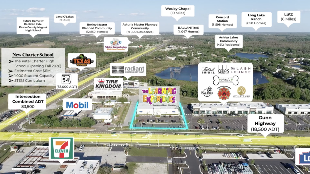
Question #3: “What’s Around It?”
Commercial real estate is fundamentally influenced by neighboring properties.
Investors understand that a property doesn’t operate in isolation. The surrounding environment often determines future performance just as much as the asset itself.
They want to know:
What businesses are nearby?
What traffic generators exist in the area?
What competing uses are present?
What residential density supports the site?
How developed is the surrounding market?
These questions help investors understand both opportunity and risk.
Unfortunately, many marketing packages focus so heavily on the subject property that they neglect the broader ecosystem.
Drone capture addresses this gap beautifully.
At medium and higher altitudes, aerial imagery provides context that static photographs simply cannot match. Investors can see shopping centers, office parks, residential developments, schools, hospitals, industrial facilities, and transportation infrastructure surrounding the asset.
They can identify complementary businesses that support tenant success and potential competitive threats that may impact performance.
Most importantly, they can evaluate the property as part of a larger market rather than as a standalone building.
This broader perspective is often where investment conviction begins to form.
Question #4: “What Am I Not Seeing?”
This may be the most important question investors ask—and it’s often the one brokers never hear.
Experienced investors are naturally skeptical.
When they review a marketing package, they aren’t just analyzing what is shown. They are actively wondering what might be missing.
What’s behind the building?
What’s beyond the edge of the photo?
What’s across the street?
What wasn’t photographed?
This isn’t distrust. It’s due diligence.
Investors know that traditional photography can unintentionally—or sometimes intentionally—hide important details.
Perhaps there’s a neighboring industrial facility.
Maybe there’s an aging retail center nearby.
Possibly there’s a drainage issue, railroad track, or utility easement that affects the property.
Drone footage dramatically reduces these concerns.
By providing comprehensive aerial coverage from multiple directions and elevations, drone imagery creates transparency. Investors gain confidence because they feel like they’re seeing the complete picture.
This transparency matters.
The more confident investors feel that they’re seeing everything, the less energy they spend searching for hidden risks.
And when investors stop looking for what’s missing, they can focus on evaluating what’s actually there.
Question #5: “How Does This Property Fit Into The Bigger Market?”
Beyond visibility, access, and surrounding uses, investors ultimately want to understand a property’s role within the broader market.
Is this location positioned within a growing corridor?
Does nearby development suggest future appreciation?
Is infrastructure investment supporting long-term growth?
How does this asset connect to larger economic trends?
These questions are difficult to answer through traditional photography.
Drone capture provides a unique advantage because it bridges the gap between property-level details and market-level understanding.
Higher-altitude imagery reveals development patterns, growth corridors, transportation networks, and commercial clusters. Investors can begin to see how the property fits within the larger story of the market.
This perspective is particularly valuable for out-of-state investors who may have little familiarity with the area.
Rather than relying solely on demographic reports and broker commentary, they gain a visual understanding of how the market is evolving around the asset.
That understanding often becomes the foundation for investment conviction.
Why Answering Questions Early Matters
Every unanswered question introduces friction into a deal.
Questions lead to emails.
Emails lead to delays.
Delays create uncertainty.
And uncertainty slows transactions.
The most effective commercial real estate marketing packages don’t simply present information—they proactively eliminate uncertainty.
This is why drone capture has become such a powerful tool in CRE.
It shortens the path between curiosity and confidence.
Instead of forcing investors to request additional information, drone footage delivers answers immediately.
The result is a smoother evaluation process, more productive conversations, and often faster movement toward due diligence and offers.
The Up Sonder Difference
At Up Sonder, we approach drone capture with this philosophy in mind.
Our goal is not simply to create visually appealing content. Our goal is to create clarity.
Every commercial drone shoot is designed to answer the questions investors are already asking. Through structured shot lists, multiple altitude layers, directional coverage, and market-context framing, we ensure that investors gain a complete understanding of the asset and its surroundings.
With a nationwide network of professional drone pilots, standardized capture protocols, and commercial real estate expertise, Up Sonder helps brokers present properties in a way that builds confidence and reduces friction.
Because the best drone footage doesn’t just show a property. It explains it.
Every investor asks the same questions.
How visible is the property?
How accessible is it?
What’s around it?
What am I not seeing?
How does it fit into the bigger market?
The faster those questions are answered, the faster investors can move toward a decision.
Professional drone capture accomplishes exactly that. It transforms listings from collections of photos into complete visual stories that eliminate uncertainty and build confidence.
In today’s commercial real estate market, that’s more than marketing.
It’s a competitive advantage.
If you’re ready to give investors the clarity they’re looking for, visit UpSonder.com and discover how strategic drone capture can help your next listing stand out, build trust faster, and move deals forward.